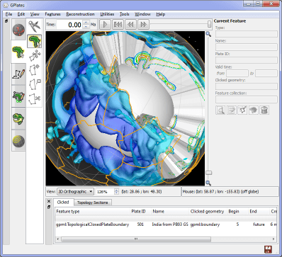
GPlates 1.3 released
What's new in version 1.3:-
- Integration of Orange and GPlates as a data mining toolkit suite.
- Includes Orange widgets to obtain pre-processed (co-registration) data from GPlates via network socket requests.
- New GPlates Rotation (GROT) file format:
- Extends PLATES4 rotation format to include a much richer set of metadata attributes.
- Please visit the GPlates Rotation (GROT) page for more details.
- Surface relief lighting:
- Visually transpose one raster onto another in the form of relief/height map shading.
- Volume visualisation of 3D scalar fields (early preview functionality):
- Developed in collaboration with Tobias Pfaffelmoser (Technical University Munich).
- For more details please see A Custom Implementation for Visualizing Sub-surface 3D Scalar Fields in GPlates
- To be officially released in GPlates 1.4.
- This release (1.3) contains preview functionality available to advanced users:
- Requires the "--enable-scalar-field-import" command-line switch to enable scalar field import.
- For example, "cd C:\Program Files (x86)\GPlates\GPlates 1.3.0" and "gplates-1.3.0.exe --enable-scalar-field-import".
- Enables menu item 'File -> Import -> Import 3D Scalar Field...'
- SVG export includes rasters, 3D scalar fields and filled polygons.
- Export arbitrary resolution rasters (eg, 3,000 x 3,000 pixels).
- Support for reading the OGRGMT file format ('.gmt').
- New finite rotation calculator utilities.
- New velocity imports/exports:
- Velocity domain generators for Terra and Lat/Lon meshes.
- Export velocities to Terra (text), CitcomS global and GMT formats.
- Calculate velocities in "Calculated Velocity Fields" layer:
- 'of domain points' - calculate velocities of reconstructed points.
- 'of surfaces' - calculate velocities of surfaces that intersect domain points.
- Enhanced velocity arrow display controls including screen space density and arrow scaling.
- New topological 'line' tool creates dynamic polylines.
- Canvas tools grouped into workflow tabs.
- Centralised GPlates Geological Information Model (GPGIM):
- GPGIM stored in a single XML file.
- All GPlates dialogs now conform to this central GPGIM.
- Features can now have either topological (dynamic) geometries or static geometries.
- Upgrades to Manage Feature Collections dialog including sort-by-filename and group selections.
- GPlates now contains a small assortment of commands (on the command-line):
- Commands are specified on the command-line and do not invoke the graphical interface of GPlates.
- Run GPlates with "--help" to list the commands and the options available to each command.
- However, in future, we will be recommending our GPlates Python programming interface (work in progress).
- Filled polygons in 2D map views.
- Improved filled polygon performance.
- Filled polygon opacity and intensity controls.
- Raster reconstruction now works with 'self-intersecting' polygons:
- Should mostly fix holes in reconstructed rasters due to missing polygons.
- 'age' colour palette button in raster layer (to use when loaded raster is an age grid).
...and many other changes that are listed in the CHANGELOG file in the GPlates source-code releases.
GPlates 1.3 compiles and runs on Windows 7/Vista/XP, Linux and MacOS X. Download GPlates 1.3 from the Download page.
GPlates-compatible data have been made available. For more information, see the Download page.
